|
|
|
|
|||||||||||||||||||||||||||||||||||||||
|---|---|---|---|---|---|---|---|---|---|---|---|---|---|---|---|---|---|---|---|---|---|---|---|---|---|---|---|---|---|---|---|---|---|---|---|---|---|---|---|
|
1998
PRELIMINARY REPORTS |
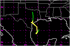
Frances was a tropical storm that brought more than 15 inches of rainfall to portions of east Texas, about ten inches in southern Louisiana, and lesser amounts were spread northward across Oklahoma, Arkansas, Kansas, Missouri, and Iowa. a. Synoptic HistoryFrances formed within a broad area of low pressure which
first showed signs of organization of its associated convective cloudiness
on 4 September. The convection was widespread over the western Caribbean
and southern Gulf of Mexico, but there was no well-defined low-level center
of circulation. This situation persisted for several days as the system
moved slowly west-northwestward and during this time three poorly-defined
closely-spaced tropical waves moved into the area, perhaps contributing
to the development of this system. By the 8th, the system developed a
1000-mb central surface pressure and considerable organized deep convection
over a large area of the western Gulf of Mexico. The best track is listed
and begins as a tropical depression at this time at a position about 140
nautical miles east of Brownsville, Texas. The tropical cyclone formation described above, with its
large size, loosely organized convection and lack of a distinct center,
is known as a "monsoon depression" in the western North Pacific basin. The tropical depression drifted southward for about a day.
By 1800 UTC on the 10th, wind observations from a data buoy, reconnaissance
aircraft, and several oil rigs indicated that Frances had strengthened
to a 40-mph tropical storm. It began moving north to northwestward at
12 to 17 mph. The center moved inland across the Texas coast just north
of Corpus Christi at 0600 UTC on the 11th. By this time, Frances had strengthened
to 63 mph under a large anticyclone aloft, weak vertical shear and SST's
near 30 degrees Centigrade. After moving inland, the center moved in a small cyclonic
loop for 12 hours between Corpus Christi and Victoria and then moved northward
across eastern Texas as a weakening tropical depression. The best track
ends at 1800 UTC on the 13th, when the center was near the Texas/Oklahoma
border north of Dallas, but the remnant low pressure and rainfall were
tracked northward to Iowa during the next 24 hours. b. Meteorological statistics Tropical storm force wind speeds were observed at several
data buoy and oil rig locations in the western Gulf of Mexico. The CMAN
station at Sabine Texas reported a maximum 2-minute wind speed of 51 mph;
this is the highest sustained surface wind speed in Table 2(a). Tropical
storm force sustained winds were observed over land at Galveston, Victoria,
and Jefferson County Airport, Texas. Frances was a large storm and the
39-mph wind speed radius extended approximately 300 nautical miles north
and east of the center. 1. Storm Surge DataStorm surge flooding of up to six to eight feet occurred
along the middle and upper Texas coast and up to 5 feet along the Louisiana
coast. This flooding persisted for about 48 hours. 2. Rainfall DataFreshwater flooding from rainfall was the most significant
weather effect. Frances dropped copious amounts of rain over east Texas
and southern Louisiana. The highest total reported in Texas was over 16
inches in Brazoria County and the highest total from Louisiana was over
11 inches. Undoubtedly, even higher amounts are likely to have accumulated
in these areas. c. Casualty and damage statisticsThere was 1 death attributed to Frances; 1 in Louisiana. Moderate beach erosion occurred along much of the upper Texas
and western Louisiana coastlines. Three Texas counties and four Louisiana parishes have been
declared as federal disaster areas, primarily due to the rainfall flooding
in the wake of Tropical Storm Frances. These include including Brazoria,
Galveston, and Harris Counties and the parishes of Cameron, Jefferson,
Lafourche and Terrebonne. The American Insurance Association reports that a total of $110 Million in insured property damage has been claimed in Texas, Louisiana and Mississippi. The Houston Chronicle reported that $256 Million in damage was inflicted in Galveston County. The total NHC damage estimate for Frances is $500 Million.
Maximum
Sustained Winds For Tropical Storm Frances
Minimum
Pressure For Tropical Storm Frances
Landfall
for Tropical Storm Frances
| ||||||||||||||||||||||||||||||||||||||