|
|
|
|
|||||||||||||||||||||||||||||||||||
|---|---|---|---|---|---|---|---|---|---|---|---|---|---|---|---|---|---|---|---|---|---|---|---|---|---|---|---|---|---|---|---|---|---|---|---|
|
1998
PRELIMINARY REPORTS |
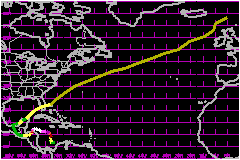
Mitch is responsible for over nine thousand deaths predominately from rain-induced flooding in portions of Central America, mainly in Honduras and Nicaragua. This makes Mitch one of the deadliest Atlantic tropical cyclones in history, ranking only below the 1780 "Great Hurricane" in the Lesser Antilles, and comparable to the Galveston hurricane of 1900, and Hurricane Fifi of 1974, which primarily affected Honduras. a. Synoptic HistoryThe origins of Mitch can be traced back to a tropical wave
that moved across the southern portion of west Africa on 8/9 October.
Rawinsonde data from Abidjan, Cote D' Ivorie, located about 980 nautical
miles southeast of Dakar, suggests that the wave had passed through the
region around 8 October. The wave crossed the west coast of Africa, generally
south of 15 North, on 10 October. The wave progressed across the tropical
Atlantic for the next seven days with west-southwesterly upper-level winds
preventing significant development. After moving through the eastern Caribbean Sea on the 18th
and 19th, satellite pictures showed an organizing cloud pattern over the
south-central Caribbean Sea on the 20th. Shower and thunderstorm activity
continued to become better organized in the southwest Caribbean Sea early
on the 21st. Subsequently, a U.S. Air Force Reserve (USAFR) reconnaissance
aircraft was dispatched to investigate the disturbance that afternoon
and found winds of 45 mph at the 1500-foot flight level, and a central
pressure of 1001 mb. On this basis, the system became a tropical depression
at 0000 UTC 22 October, about 360 nautical miles south of Kingston, Jamaica.
The depression moved slowly westward and strengthened to a tropical storm
later that day, about 225 nautical miles east-southeast of San Andres
Island, while moving in a cyclonic loop. By the 23rd, the intensification
of Mitch was disrupted by westerly vertical wind shear associated with
an upper-level low north-northwest of the tropical cyclone. Later on the
23th, the upper low weakened, the shear diminished, and Mitch began to
strengthen while moving slowly northward. Mitch became a hurricane at 0600 UTC 24 October while located
about 255 nautical miles south-southwest of Kingston, Jamaica. Later that
day, as it turned toward the west, Mitch began a period of rapid intensification.
During a 24 hour period beginning on the afternoon of the 24th, its central
pressure dropped 52 mb, to 924 mb. With a symmetric, well-established
upper-tropospheric outflow pattern evident on satellite imagery, the hurricane
continued to strengthen. On the afternoon of the 26th, the central pressure
reached a minimum of 905 mb, while the cyclone was centered about 50 nautical
miles southeast of Swan Island. This pressure is the fourth lowest ever
measured in an Atlantic hurricane, tied with Hurricane Camille in 1969.
This is also the lowest pressure ever observed in an October hurricane
in the Atlantic basin. Prior to Mitch, the strongest measured hurricane
in the northwest Caribbean was Hurricane Haiti in 1961 with a central
pressure of 924 mb. At its peak on the 26th, Mitch's maximum sustained
1-minute surface winds were estimated to be 178 mph, a category five hurricane
on the Saffir/Simpson Hurricane Scale. After passing over Swan Island on the 27 October, Mitch
began to gradually weaken while moving slowly westward. It then turned
southwestward and southward toward the Bay Islands off the coast of Honduras.
The center passed very near the island of Guanaja as a category four hurricane.
Mitch slowly weakened as its circulation interacted with the land mass
of Honduras. From mid-day on the 27th, to early on the 29th, the central
pressure rose 59 mb. The center of the hurricane meandered near the north
coast of Honduras from late on the 27th through the 28th, before making
landfall during the morning of the 29th about 70 nautical miles east of
la Ceiba with estimated surface winds of 98 mph and a minimum central
pressure of 987 mb. After making landfall, Mitch moved slowly southward, then
southwestward and westward, over Honduras, weakening to a tropical storm
by 0600 UTC 30 October, and to a tropical depression by 1800 UTC 31 October. The overall motion was slow, less than 5 mph, for a week.
This resulted in a tremendous amount of rainfall, estimated at up to 35
inches, primarily over Honduras and Nicaragua. The heavy rainfall resulted
in flash floods and mudslides that killed thousands of people. It is noted
that a large east-west mountain range, with peaks approaching 10,000 feet,
covers this part of Central America and this terrain likely contributed
to the large rainfall totals. Some heavy rains also occurred in other
portions of Central America. Although Mitch's surface circulation center dissipated near
the Guatemala/Mexico border on 1 November, the remnant circulation aloft
continued to produce locally heavy rainfall over portions of Central America
and eastern Mexico for the next couple of days. By the afternoon of 2 November, meteorologists at the Tropical
Prediction Center/National Hurricane Center (NHC) Tropical Analysis and
Forecast Branch (TAFB), and the Satellite Analysis Branch (SAB) of the
National Environmental Satellite, Data, and Information Service began
to follow a cloud-system center, the remnants of Mitch, in satellite imagery
over the Bay of Campeche. Shower and thunderstorm activity began to increase
later on the 2nd. On 3 November, a low-level circulation became evident
in the eastern Bay of Campeche. A USAFR aircraft sent to investigate the
system later that afternoon found 52 mph winds at 1500 feet and a minimum
central pressure of 997 mb. Thus, advisories were re-initiated on Tropical
Storm Mitch located about 130 nautical miles southwest of Merida, Mexico.
Mitch moved northeastward and weakened to a depression early on the 4th
after it made landfall over the northwestern Yucatan peninsula. The center
re-emerged over the south-central Gulf of Mexico by mid-morning on the
4th, and Mitch regained tropical storm strength. The storm began to accelerate
northeastward as it became involved with a frontal zone moving through
the eastern Gulf of Mexico. Mitch made landfall on the morning of 5 November
in southwest Florida near Naples, with estimated maximum sustained winds
of 63 mph. Mitch continued to move rapidly northeastward and by mid-afternoon
of the 5th, moved offshore of southeastern Florida and became extratropical.
The extratropical cyclone accelerated northeastward across the North Atlantic
Ocean from the 6th through the 9th. b. Meteorological StatisticsMost of the aerial reconnaissance flights into Mitch were
by the USAFR "Hurricane Hunters. The Hurricane Hunters flew 19 missions,
and made 41 center fixes while NOAA aircraft performed 2 missions contributing
9 center fixes. The highest 700-mb flight-level wind report was 193 mph
at 1900 UTC 26 October by the USAFR. This wind speed was observed 14 nautical
miles northeast of the center near the time of a 905 mb GPS dropsonde-measured
pressure. A dropsonde in the northeast eyewall showed winds to near 184
mph at 900 mb, but lower speeds below that altitude. The highest satellite-based
intensity estimate, obtained by both objective and subjective methods,
was 178 mph on the 26th and the 27th. 1. Rainfall DataRainfall observations from Honduras, with a maximum of 35.89
inches from Choluteca. Even higher values may have gone unobserved. 2. TornadoesFive tornadoes were spawned by Mitch in South Florida: two
in the Florida Keys, one each in Broward, Palm Beach, and Collier Counties.
The most significant of these (F2 intensity) occurred in the upper Florida
Keys, Islamorada to North Key Largo. c. Casualty and Damage StatisticsThere were 9,086 deaths attributed to Mitch; 5677 in Honduras,
2,863 in Nicaragua, 258 in Guatemala, 239 in El Salvador, 9 in Mexico
and 7 in Costa Rica. Mitch also claimed two lives in Monroe County, Florida. Both
deaths were drowning-related incidents resulting from a fishing boat capsizing. It has been estimated that there was a 50 percent loss to
Honduras' agricultural crops. At least 70,000 houses were damaged and
more than 92 bridges were damaged or destroyed. There was severe damage
to the infrastructure of Honduras and entire communities were isolated
from outside assistance. To a lesser extent, damage was similar in Nicaragua,
where a large mudslide inundated ten communities situated at the base
of La Casitas Volcano. Guatemala and El Salvador also suffered from flash
floods which destroyed thousands of homes, along with bridges and roads. The Florida tornadoes injured 65 people and damaged or destroyed
645 homes. Insured property damage supplied by the Florida insurance Council puts the insured damage estimate for Florida at $20 Million. These estimates exclude storm surge damage. To determine the total estimated damage, a ratio of 2:1 is applied to the insured property damage; this is based on comparisons done in historical hurricanes. Thus, the U.S. total estimated damage from Mitch is $40 Million.
Maximum Intensity For Hurricane Mitch
Landfall
for Hurricane Mitch
| ||||||||||||||||||||||||||||||||||