|
|
|
|
|||||||||||||||||||||||||||||
|---|---|---|---|---|---|---|---|---|---|---|---|---|---|---|---|---|---|---|---|---|---|---|---|---|---|---|---|---|---|
|
1998
PRELIMINARY REPORTS |
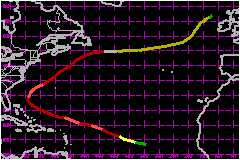
Danielle had a long track across the Atlantic. Although it did not seriously impact land as a tropical cyclone, it battered portions of Great Britain as an extratropical system. a. Synoptic HistoryA tropical wave moved off the west coast of Africa on 21
August accompanied by disorganized cloudiness and showers. Within 24 hours,
deep convection became somewhat more consolidated in clusters near an
ill-defined center of cyclonic cloud rotation. Initial Dvorak technique
classifications were assigned at 1100 UTC 22 August. Thereafter, the organization
of the disturbance continued to gradually improve as cloudiness and showers
became concentrated in a circular area. By 0600 UTC 24 August, the Dvorak
T-number was analyzed at 2.0 and it is estimated that Tropical Depression
Four formed around this time, centered a little less than 600 nautical
miles west-southwest of the Cape Verde Islands. Strengthening continued,
as satellite images showed convection becoming more tightly wrapped around
the center, and the tropical cyclone is estimated to have become Tropical
Storm Danielle by 1800 UTC 24 August. Upper-tropospheric outflow was well-defined
over the area, and Danielle intensified further. The first visible satellite
pictures on 25 August revealed a "pinhole" eye, indicating that the system
had become a hurricane. Danielle was a quite compact system, with tropical
storm force winds covering an area estimated to be only a little more
than 100 nautical miles in diameter. Based on satellite data, this rapidly
strengthening hurricane reached a peak intensity of near 104 mph around
0600 UTC 26 August, while centered about 900 nautical miles east of the
Leeward Islands. After reaching its first peak in strength, some southeasterly
vertical shear appeared to disrupt Danielle's organization. By the time
the first reconnaissance aircraft reached the hurricane around 0000 UTC
27 August, the system was not as well-organized on satellite imagery as
it had been. This first aircraft mission found a maximum wind of 104 mph
at the 850 mb flight level, but a remarkably high central pressure of
993 mb. Such values of wind and pressure show how much deviation from
the typical wind vs. pressure relationship can occur in compact hurricanes.
In contrast to this, the much larger Hurricane
Bonnie, which was in progress over the western Atlantic around the
same time with a comparable maximum wind speed, had a minimum central
pressure that was 25 mb lower than the value noted in Danielle. Moderate vertical shear continued to preclude much strengthening
of Danielle. However, aircraft data indicate that a second 104-mph intensity
peak occurred around 1200 UTC on the 27th. For the next few days, some
weakening took place even though the eyewall structure was generally maintained
and atmospheric conditions seemed to be favorable for intensification.
By the 30th, Danielle was barely of hurricane strength. Movement over
waters that were cooled by the earlier passage of Hurricane
Bonnie may have been the main cause of weakening, but this is uncertain. From the time the cyclone formed, and for about six more
days, the motion was toward the west-northwest, with the forward speed
gradually slowing from 21-23 mph over the eastern Atlantic to 10 or 12
mph on 30 August. By the latter time, Danielle was nearing the western
periphery of the subtropical anticyclone which had steered it across much
of the Atlantic. Continuing to decelerate, the hurricane turned toward
the northwest and north, reaching its westernmost longitude, about 74°W,
early on the 31st. The hurricane began to restrengthen, and a third 104-mph
intensity peak was noted around 1200 UTC that day. In response to increasing southwesterly mid-tropospheric
steering flow, ahead of a trough near the United States east coast, Danielle
completed its recurvature and began to move northeastward on 1 September.
It also regained 104-mph maximum winds for the fourth, and final, time.
The center of the accelerating hurricane passed slightly less than 200
nautical miles northwest of Bermuda early on the 2nd. Danielle began to
lose its tropical characteristics on 3 September, as its center passed
about 200 nautical miles south of Cape Race, Newfoundland. It is estimated
that Danielle became an extratropical cyclone by 0000 UTC 4 September,
although it was still a strong storm with hurricane force winds. The storm
moved eastward to east-northeastward across the north Atlantic for the
next couple of days, with only slow weakening. It turned northeastward
several hundred miles to the west of the British Isles on the 6th, its
forward speed slowing to 7-12 mph. The cyclone became indistinct when
it merged with another extratropical low a couple hundred miles north
of Ireland on 8 September. b. Meteorological StatisticsThe highest wind reported in Danielle was 112 mph, at 700
mb from the Hurricane Hunters at 1141 UTC 27 August. Additional Hurricane
Hunter wind observations of 110 mph at 850 mb and 106 mph at 700 mb were
taken at 1235 UTC 31 August and 1656 UTC 1 September, respectively. These
data, along with satellite-based intensity estimates on 26 August, are
the main bases for the four intensity peaks of 104 mph in the best track.
The minimum pressure estimate, 960 mb, was derived from a lowest pressure
observation of 962.6 mb from the (Canadian) Laurentian Fan buoy, 44141
at 0900 UTC 3 September. This observation, as well as other ship and buoy
reports of tropical storm force or greater windspeeds associated with
Danielle, are listed in Table 2. It is also noteworthy that the aforementioned
buoy measured a significant-wave height of 52 feet with a maximum wave
height of 88 feet at the time of its lowest pressure. Sustained winds of 39 mph with gusts to 54 mph were observed
at Bermuda at 1100 UTC 2 September. c. Casualty and Damage StatisticsNo reports of casualties due to Danielle have been received at the National Hurricane Center. The western part of Great Britain was lashed by Danielle as an extratropical storm on 6 September. Several persons were rescued from treacherous sea conditions in the area. On the coast of Cornwall, beach areas had to be evacuated after waves became so high that they were breaking over some houses. A police all-terrain vehicle on the Isles of Scilly was swept into the sea by a rogue wave as it was being driven down a concrete pier in one of the island's main towns.
Maximum
Sustained Winds For Hurricane Danielle
Minimum
Pressure For Hurricane Danielle
| ||||||||||||||||||||||||||||