|
|
|
|
|||||||||||||||
|---|---|---|---|---|---|---|---|---|---|---|---|---|---|---|---|
|
1998 PRELIMINARY
REPORTS |
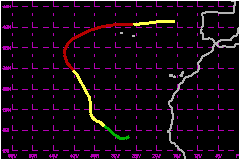
a. Synoptic HistoryHurricane Ivan was the first in a trio of hurricanes to form
and then remain over the eastern Atlantic Ocean during the latter part
of September. The wave from which Ivan developed was rather easily identified
by its concentrated area of thunderstorms seen on satellite pictures over
western Africa near the Greenwich Meridian on 14 September. Although deep
convection diminished when the wave neared the coast, the residual cloudiness
and sounding data up through 700 mb from Dakar, Senegal showed the system's
passage into the Atlantic on the 16th. Strong convection associated with the wave redeveloped to
the south of the Cape Verde Islands on the 17th. Position estimates from
satellite analysts began that day. The cloudiness became more concentrated
near the apex of the wave on the 18th. Late that day, Dvorak T-numbers
first reached 2.0 from the NOAA TPC Tropical Analysis and Forecast Branch
(TAFB) and 1.5 from the NOAA Synoptic Analysis Branch (SAB). Slow development
followed and it is estimated that the system became a tropical depression
near 0000 UTC on the 19th, about 175 nautical miles to the southwest of the Cape
Verde Islands. The tropical cyclone was influenced by mid- to upper-level
cyclonic flow centered to its northwest, over the central Atlantic. At
first, that pattern consisted of a trough elongated southward from 30N.
During Ivan's development, however, water vapor imagery showed the trough
become a closed circulation that partially enveloped the tropical cyclone.
A second trough later affected Ivan as well. These features influenced
the details of Ivan's track, which was generally northwestward at 12-17
mph from the 20th-25th. The troughs also created an environment of vertical shear
that led to Ivan's rather slow development. Ivan became a tropical storm
late on the 20th and during the following 48 hours wind speeds increased
to around 63 mph as estimated from the appearance of what could have
been an eye on satellite pictures for about an hour. Ivan's hurricane stage occurred rather far to the north.
At 1400 UTC on the 23rd, the eye reappeared and was more prominent than
earlier, indicating that Ivan was becoming a hurricane as it neared 30N.
After again disappearing, the eye became its most distinct with a diameter
of about 20 nautical miles, and Ivan is estimated to have reached its peak intensity
of about 92 mph on the morning of the 26th. The hurricane was then located
about 300 nautical miles to the west of the Azores Islands. At that time, the influence
of the upper troughs on Ivan was decreasing and the track of the hurricane
was increasingly controlled by the westerlies just to the north. Late
on the 26th, the eye disappeared. The inner convective structure rapidly
deteriorated while Ivan passed eastward over cooler waters to the north
of the Azores Islands on the 27th. Ivan was then becoming a weakening
extratropical storm, and then gale, which moved northeastward according
to analyses issued in the United Kingdom. b. Meteorological StatisticsThere were no reports of tropical storm force winds on land. The ships listed below reported sustained tropical storm
force winds. The reports of northerly or northwesterly winds of 40-44
mph from the ship DACF near 16N 25W on 19 September do not seem
compatible with other ship reports in that vicinity, or with the analysis
of the cyclone--centered a few hundred nautical miles to the southwest
at that time. In addition, the speeds shown for ship PJOX at 23/1800
UTC and 24/0300 UTC are probably double the actual winds based on analysis
of data by the NWS Marine Prediction Center. c. Casualty and Damage StatisticsIvan is not known to have caused casualties or damages.
Maximum
Intensity For Hurricane Ivan
| ||||||||||||||