|
|
|
|
|||||||||||||||||||||||||||||||||||||||
|---|---|---|---|---|---|---|---|---|---|---|---|---|---|---|---|---|---|---|---|---|---|---|---|---|---|---|---|---|---|---|---|---|---|---|---|---|---|---|---|
|
1998
PRELIMINARY REPORTS |
Earl made landfall on the Florida panhandle as a category 1 hurricane on the Saffir/Simpson Hurricane Scale (SSHS), resulting in significant storm surge flooding in the "Big Bend" area of Florida. a. Synoptic HistoryHurricane Earl formed from a strong tropical wave that emerged
from the west coast of Africa on 17 August. Persistent convection accompanied
the wave as it moved westward across the tropical Atlantic. A weak surface
cyclonic circulation was suggested in animation of satellite imagery,
as well as in limited aircraft reconnaissance and island reports as the
system passed through the Lesser Antilles on 23 August. Tropical cyclone
development appears to have been inhibited while the system moved through
the Caribbean by unfavorable winds aloft. These unfavorable conditions
were a result of the upper-level outflow from large and powerful Hurricane
Bonnie located over the southwest North Atlantic and moving toward
the North Carolina coast. Nevertheless, the tropical wave continued to
be easily tracked in satellite imagery as it moved into the Gulf of Mexico
where cloudiness and thunderstorms increased. The post-analysis "best
track" shows that the system became a tropical depression over the southwest
Gulf of Mexico midway between Merida and Tampico, Mexico at 1200 UTC 31
August. The tropical depression became Tropical Storm Earl while
centered about 500 n mi south-southwest of New Orleans, Louisiana near
1800 UTC 31 August based on aircraft reconnaissance data. The center remained
difficult to locate by satellite, and, in fact, multiple centers were
reported by aircraft reconnaissance for the next couple of days. Occasionally,
a new center would appear to form which made tracking extremely difficult.
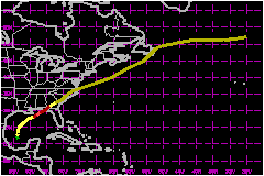
Although the best track shown in Figure 1 indicates a general motion toward
the north and then northeast near 12 mph while Earl was over the Gulf
of Mexico, a certain amount of "smoothing" was necessary to account for
the multiple centers and any possible center reformations. Based on aircraft reconnaissance data, Earl is estimated
to have reached hurricane status at 1200 UTC 2 September while centered
about 125 n mi south-southeast of New Orleans, Louisiana. The system never
exhibited a classical hurricane appearance. Instead, satellite imagery
showed the deepest convection confined primarily to the eastern quadrants
of the circulation and aircraft reconnaissance data indicated a very asymmetric
wind field with the strongest winds located well east and southeast of
the center. After briefly reaching category 2 status on the SSHS, Earl
made landfall near Panama City, Florida as a category 1 hurricane near
0600 UTC 3 September. The strongest winds remained well to the east and
southeast of the center which resulted in the highest storm surge values
in the Big Bend area of Florida, well away from the center. The tropical
cyclone weakened to below hurricane strength soon after making landfall,
and became extratropical at 1800 UTC 3 September while moving northeastward
through Georgia. The deepest convection became well removed from the center
by this time and the strongest winds were located over the Atlantic waters
off the U.S. southeast coast. The extratropical cyclone moved off the
mid Atlantic coast near 1800 UTC 4 September, crossed over Newfoundland
on 6 September and was tracked across the North Atlantic until being absorbed
by a larger extratropical cyclone (formerly Hurricane
Danielle) on 8 September. b. Meteorological StatisticsThe operational aircraft reconnaissance flights into Earl
were provided by the U.S. Air Force Reserves. The minimum central pressure
reported by aircraft was 985 mb at 0045 UTC 3 September. This minimum
pressure was measured by dropsonde and was the lowest pressure reported
during Earl's existence. The maximum winds of 120 mph from a flight level
of 850 mb (near 5,000 feet) were measured at 1638 UTC 2 September. These
peak winds were in a limited area about 80 n mi east of the center. The
Hurricane Hunters never reported an eyewall. Reconnaissance data and land-based
radar presentations suggest the hurricane weakened before moving onshore. Satellite estimates underestimated the intensity of Earl,
likely due to the fact that Earl never exhibited a classical tropical
cyclone pattern. For example, the maximum winds estimated from the Tropical
Analysis and Forecast Branch (TAFB), the tropical branch of the Air Force
Weather Agency (AFGWC in figures) and the Synoptic Analysis Branch (SAB)
were 63 mph, 63 mph and 52 mph, respectively. The WSR-88D (Weather Surveillance Radar - 1988 Doppler) at
Slidell, Louisiana, Mobile, Alabama, Eglin Air Force Base, Florida and
Tallahassee, Florida were helpful in locating the center and areas of
strongest winds aloft as the cyclone moved near shore. As is often the case in landfalling hurricanes, there were
no reports from land stations of sustained hurricane force winds in Earl.
Table 2 lists selected U.S. surface observations. The NOAA C-MAN station
at Cape San Blas (near Apalachicola, Florida) reported 10-minute sustained
winds of 55 miles between 0400 and 0500 UTC and gusts to 70 mph at 0436
UTC 3 September. The strongest winds at the time of landfall likely remained
over water near the Big Bend area of Florida. Several wind reports from north Florida were relayed to the
NHC through amateur radio volunteers. The highest measured wind gust was
91 mph at an elevation of 33 feet from a Davis wind instrument located
in the middle of St. George Island at 29.40N 84.53W at 0102 UTC 3 September.
Although these measurements are very much desired to supplement the more
official observations, they will not be listed in Table 2 unless their
accuracy can be verified. A rather extensive sampling of the Gulf of Mexico with GPS
dropwindsondes by the NOAA jet, centered around 0000 UTC 2 September,
showed a mid-level trough extending into the central Gulf which provided
the steering currents that moved Earl northeastward into the Florida panhandle. 1. Storm Surge DataStorm surge was estimated to be near 8 feet in Franklin,
Wakulla, Jefferson and Taylor Counties and approximately 6 to 7 feet in
Dixie County. These values tapered off to between 2 to 3 feet in Lee County. 2. Rainfall DataRainfall totals of three to six inches were common near the
path of Earl, although much higher amounts were recorded in a few areas.
A storm total of 16.38 inches near Panama City, Florida, was the highest
reported. 3. TornadoesSeveral tornadoes were reported in central and north Florida,
Georgia, and South Carolina. c. Casualty and Damage StatisticsThere were 3 deaths attributed to Earl; 2 in Florida and
1 in South Carolina. The Property Claim Services Division of the American Insurance Services Group estimates that Earl caused insured property damage of $15 Million in Florida, $1 Million in Georgia, and $2 Million in South Carolina. These estimates do not include storm surge damage. In addition, the National Flood Insurance Program reported $21.5 Million of insured (storm surge related) losses in Florida. A conservative ratio between total damage and insured property damage, compared to past landfalling hurricanes, is two to one. Therefore, the total U.S. damage estimate is $79 Million.
Maximum
Sustained Winds For Hurricane Earl
Minimum
Pressure For Hurricane Earl
Landfall
for Hurricane Earl
| ||||||||||||||||||||||||||||||||||||||