|
|
|
|
|||||||||||||||
|---|---|---|---|---|---|---|---|---|---|---|---|---|---|---|---|
|
1998
PRELIMINARY REPORTS |
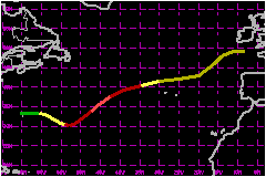
Hurricane Karl was one of four hurricanes in existence over the Atlantic basin at one time. It remained over water without any direct effects to land. a. Synoptic HistoryHurricane Karl developed from a small low of non-tropical
origin that was tracked from the coast of the Carolinas beginning on 21
September. Deep convection became better organized as the low moved eastward
and the "best track" indicates that a tropical depression formed from
the disturbance near 1200 UTC 23 September while centered about 50 nautical
miles west-northwest of Bermuda. Convective banding increased and the
system became Tropical Storm Karl that evening. The tropical cyclone began
moving east-southeastward about this time. Satellite imagery showed the gradual development of a more
symmetrical cloud pattern with the center becoming embedded within the
coldest convective tops. Karl became a hurricane near 1200 UTC 25 September
while centered about 550 nautical miles east-southeast of Bermuda. At
this time, Hurricane
Georges was over the Straits of Florida, Hurricane
Ivan was over the North Atlantic about 500 nautical miles west-southwest
of the Azores, and Hurricane Jeanne was
over the tropical Atlantic about midway between Africa and the Lesser
Antilles. Thus, Karl became the fourth hurricane to co-exist over the
Atlantic. According to records at the NHC, the last time four hurricanes
were in existence in the Atlantic at the same time was on August 22, 1893.
Records also note that on September 11, 1961, three hurricanes and possibly
a fourth existed. Karl began to move toward the northeast in response to a
large mid- to upper-level trough to the west of the hurricane. A well-defined
eye developed and it is estimated that Karl first reached a maximum intensity
of 104 mph at 0000 UTC 27 September while centered about 875 nautical
miles east-northeast of Bermuda. The eye remained distinct for at least
six hours, after which time the hurricane started to weaken primarily
due to increasing upper-level shear. The hurricane accelerated toward the northeast and weakened
to a tropical storm by 0000 UTC 28 September while centered over 23C water
about 175 nautical miles west-northwest of the westernmost Azores. Karl
continued moving over increasingly cooler waters and became extratropical
later on the 28th as the circulation center became well removed from any
deep convection. The extratropical cyclone was tracked to south of Ireland
by late on the 29th. b. Meteorological StatisticsAs usual for a tropical cyclone not threatening land, satellites
provided the primary source of observational data. Dvorak technique location
and intensity estimates from the satellite data were produced by the Air
Force Weather Agency (AFGWC in figures), the NOAA Synoptic Analysis Branch
(SAB) and the NOAA Tropical Analysis and Forecast Branch (TAFB). The highest
official Dvorak T number was 5.0 (104 mph) from TAFB and SAB near 0000
and 0600 UTC 27 and is the basis for estimating the peak intensity near
these times. c. Casualty and Damage StatisticsThere were no reports of casualties or damage from Karl received at the NHC.
Maximum
Intensity For Hurricane Karl
| ||||||||||||||