|
|
|
|
|||||||||||||||
|---|---|---|---|---|---|---|---|---|---|---|---|---|---|---|---|
|
1998
PRELIMINARY REPORTS |
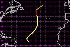
Lisa briefly reached hurricane force in the central North Atlantic Ocean and did not affect land. a. Synoptic HistoryLisa originated from a tropical wave which moved westward
from Africa into the eastern tropical Atlantic Ocean on 29 September.
The associated cloudiness was fairly well organized and centered at about
10°N latitude. By the next day, it was an almost indistinguishable
part of the Intertropical Convergence Zone(ITCZ) which was active across
the entire tropical Atlantic. By 3 October, the system became better defined
as its convection increased and the ITCZ cloudiness dissipated to its
east and west. On the 4th, midway between Africa and the Lesser Antilles,
there were signs of a low level circulation and it is estimated that a
tropical depression formed at 0000 UTC on the 5th. The depression strengthened into Tropical Storm Lisa on the
5th, although it was in an environment of strong vertical shear, as evidenced
by the low-level center being exposed to the west of the associated deep
convection. This shear was caused by an upper level low located to the
northwest of the storm. The presence of this low also weakened the ridge
to the north, causing the storm's motion to begin a turn toward the north.
During the next two days, a strong baroclinic trough in the westerlies
evolved into a deep low in the central North Atlantic. This resulted in
an acceleration toward the northeast. The forward speed reached in excess
of 58 mph by the afternoon of the 9th. The vertical shear relaxed over
the storm and it gradually strengthened. Lisa turned northward on the
9th, steered by the deep low to its west and a 1032 mb high to its east.
This strong east-west pressure gradient also resulted in increasing the
surface winds well to the east of the center and Lisa briefly strengthened
to a 75-mph hurricane on the 9th, before merging with an extratropical
frontal system in the far North Atlantic. On the 10th, it was no longer
possible to identify a well-defined circulation on satellite imagery. b. Meteorological statisticsA NOAA drifting buoy (16.6N, 46.9W) in the central tropical
Atlantic provided a wind observation of 40 mph at 0850 UTC on the 5th
and another of 41 mph at 2138 UTC. These observations were essential in
determining that Lisa had become a tropical storm, as satellite-based
intensity estimates were well below storm strength at these times. The
estimate that Lisa acquired 75-mph hurricane-force winds on the 9th was
based on satellite intensity estimates and on a report of 70 mph from
the ship ZCBD9 located at 46.9N, 33.3W at 1800 UTC (approximately
240 nautical miles east of the center). The system was rapidly transforming
into an extratropical system during this time and it is not certain that
the strongest winds were near the center. c. Casualty and damage statisticsThere were no reports of casualties or damage received.
Maximum
Intensity For Hurricane Lisa
| ||||||||||||||