|
|
|
|
|||||||||||||||||||||||||
|---|---|---|---|---|---|---|---|---|---|---|---|---|---|---|---|---|---|---|---|---|---|---|---|---|---|
|
1998
PRELIMINARY REPORTS |
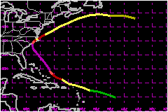
Bonnie was the third hurricane to directly hit the coast of North Carolina during the past three years. a. Synoptic HistoryThe origin of Bonnie was a large and vigorous tropical wave
that moved over Dakar, Senegal on 14 August. The wave was depicted on
visible satellite imagery by a large cyclonic low- to mid-level circulation
void of deep convection. The wave caused a 24-h surface pressure change
of -3.5 and -4.0 mb at Dakar and Sal respectively. There was a well established
700 mb easterly jet which peaked at 58 mph just before the wave axis crossed
Dakar, followed by a well marked wind-shift from the surface to the middle
troposphere. The overall circulation exited Africa basically just north
of Dakar where the ocean was relatively cool. However, a strong high pressure
ridge steered the whole system on a west-southwest track over increasingly
warmer waters and convection began to develop. Initially, there were several
centers of rotation within a much larger circulation and it was not until
1200 UTC 19 August that the system began to consolidate and a tropical
depression formed. Although the central area of the tropical depression
was poorly organized, the winds to the north of the circulation were nearing
tropical storm strength. This was indicated by ship observations and high
resolution low-cloud wind vectors provided in real time by the University
of Wisconsin. The depression was then upgraded to Tropical Storm Bonnie
based on these winds and satellite intensity estimates at 1200 UTC 20
August. Bonnie moved on a general west to west-northwest track around
the circulation of the Azores-Bermuda High toward the northern Leeward
Islands. The first reconnaissance plane reached Bonnie late on the
20th and measured a minimum pressure of 1004 mb and winds of 70 mph at
1500 feet to the northeast of the center. Bonnie skirted the Leeward Islands
and most of the associated weather remained to the north over the open
Atlantic. During that period, Bonnie's circulation was very asymmetric. Under a favorable upper-level wind environment, Bonnie gradually
strengthened and became a hurricane at 0600 UTC 22 August when it was
located about 200 nautical miles north of the eastern tip of Hispaniola.
At that time, the hurricane hunters found a nearly complete eyewall and
flight-level peak winds of 87 mph. Bonnie moved on a general west-northwest
heading and reached maximum winds of 115 mph and a minimum pressure of
954 mb about 150 nautical miles east of San Salvador in the Bahamas. The ridge to the north of Bonnie temporarily weakened and
the steering currents collapsed. The hurricane then drifted northward
for a period of 18 to 24 hours. Thereafter, the subtropical ridge reintensified,
forcing Bonnie to move northwestward and then northward toward the coast
of North Carolina while the hurricane maintained winds of 115 mph. After a slight weakening, the eye of Bonnie passed just east
of Cape Fear around 2130 UTC 26 August and then made landfall near Wilmington
as a border line Category 2/3 hurricane on the Saffir/Simpson Hurricane
Scale (SSHS) around 0330 UTC 27 August. The hurricane slowed down and weakened while moving over
eastern North Carolina. It was then downgraded to tropical storm status
based on surface observations and WSR88-D winds. Bonnie turned northeastward
over water ahead of a middle-level trough and rapidly regained hurricane
strength as indicated by aircraft reconnaissance data. Thereafter, the
hurricane moved on a general northeast to east track and became extratropical
near 1800 UTC 30 August, about 240 nautical miles south southeast of New
Foundland. b. Meteorological StatisticsThe maximum winds measured were 133 mph at the 700-mb level
at 0113 UTC 25 August and then again at 1659 UTC 26 August. These measurements
were taken during the AF963 and the NOAA 43 reconnaissance missions, respectively.
Table 2 displays selected surface observations during Bonnie, primarily
over the area where the hurricane made landfall. There were several important
and useful observations relayed to the NHC and to the local NWS forecast
offices from amateur observing reports. These include reports of peak
winds of 120 mph at 0138 UTC near NC State Port and 115 mph at Wrightsville
Beach at 1951 UTC 27 August. 1. Storm Surge DataStorm tides of 5 to 8 feet above normal were reported mainly
in eastern beaches of Brunswick County NC, while a storm surge of 6 feet
was reported at Pasquotank and Camdem counties in the Albemarle Sound. 2. Rainfall DataRainfall totals of about 8 to 11 inches were recorded in portions of eastern NC.3. TornadoesA tornado was reported in the town of Edenton NC in Chowan
County. c. Casualty and Damage StatisticsThere were 3 deaths attributed to Bonnie; 1 in North Carolina,
1 in Delaware and 1 in Maine. There are numerous reports of many trees down, roof and structural
damage and widespread power outages primarily in eastern North Carolina
and Virginia where a federal disaster was declared for several counties.
The area hardest hit appears to have been Hampton Roads, Virginia, where
the damage could reach well into the hundreds of millions of dollars. The Property Claim Services Division of the American Insurance Services Group reports that Bonnie caused an estimated $360 Million in insured property damage to the United States. This estimate includes $240 Million in North Carolina, $95 Million in Georgia, and $25 Million in South Carolina. A conservative ratio between total damage and insured property damage, compared to past landfalling hurricanes, is two to one. Therefore, the total U.S. damage estimate is $720 Million.
Maximum Intensity For Hurricane Bonnie
Landfall
for Hurricane Bonnie
| ||||||||||||||||||||||||